Backpacking 2009
Wind River Mountains, Upper Paradise to Half-Fish and Back
Even though it has been over nine months since we got back from our trip, I had to post some pictures, just a few, and give a quick trip log. I am pretty sure that all involved thought it was one of the best trips we have ever taken. We backpacked for eight days covering about 50 miles, visited about ten lakes, fished some great rivers, caught hundreds of fish, and avoided an unruly bear.
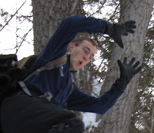
 As you can see everyone was hard at work the night before we left.
  The drive up ends with a 45 minute jaunt on a dirt road. We left Kaysville at about 6:30 a.m and arrived at the trail head at about 1:00 p.m. It rained on the entire trip up until we reached Fort Washakie. Despite this change in the weather we were sure that we would be hiking in the rain.
  Rain threatened as we unpacked the car and ate lunch. We could see snow dusting the tops of the distant peaks. The trail head elevation is about 8500 feet. Our elevation would top out at 11,000 feet five miles into the hike, definitely high enough for snow.
 The first part of the trail is flat with just a couple of up and downs. The temperature was about 50 degrees Fahrenheit, perfect for backpacking. Not so cold that you freeze, but not so warm that you sweat profusely. Well, we weren't sweating on the flat parts. I am amazed at how good I feel during the first mile of a backpacking trip. Five miles in I was wondering how I ever got my pack on my back.
  Again, early on in the trail. We crossed two creeks. The crossing have changed each time we have come up here. There are beaver dams that change the course of the creeks yearly.
  I had my camera ready to catch someone falling in. My wish was met with disappointment. I believe that this was the first trip in several years where no one fell in a creek.
Dad is looking good early on. Notice that his coat is off. Also note the brown pine tree behind him. I didn't count, but I would bet that about half of the pine trees are dead from the pine beetle. There is a picture of an infested tree later.

The early trail is also notable for the six or seven meadows that are crossed. Cows graze in this area. They were as interested in us as we were in them.


This is where the trail really begins. We are done crossing creeks for a while and the trail finally starts a steady but not steep uphill. Everyone stopped to put covers on packs and rain coats on. This was the first of about twenty changes in the weather. It would rain for 10 minutes then stop. As soon as the coats came off it would start raining again. We would try to endure the rain as long as we could knowing that it would soon stop. Unfortunately it would not stop until we had put our rain gear on. Welcome to the mountains.

I had never seen a tree infected by pine beetles up close before. I grew up hearing stories about how the pine beetle devastated the forests in Island Park in the 1970s.
 As you can see the beetles are small and are on the outside of the bark. That is all I know about them. There is more beetle information on Wikipedia.
I like this picture not because it looks like Jon is itching his bum, but because Spencer was somehow able to move his head exactly with the shake of my hand (the shot was taken at a slow shutter speed). We have just crossed a creek and are about 2 miles into the hike. From here on the trail gets very steep. I would guess that we had climbed about 500 feet. Only another 2000 to go.

Trying to show how steep the trail is is difficult. Even though Jon is only about 15 feet from me he is about 4 feet lower that I am. This is not the steepest part of the trail.

I thought I should have a least one pictures of me in this post.

About one mile from the pass the trees thin and the trail becomes very steep. The wind also picks up. It was blowing from West to East. The headwind makes the trip up that much more difficult.

Just a shot looking East back down the trail.
 Looking West, up the trail again. Photos are a great excuse to stop and catch one's breath.
 When I reached the top of the pass it was snowing it felt like it was about 20 degrees and the wind was blowing about 50 mph. I didn't even pause at the top. After hiking down the other side for only five minutes the snow stopped, the sun came out, and the wind calmed down. The hard part of the day was done.
 As the clouds broke the sun came out offering some good lighting for some dramatic pictures.
 Jon and Spencer were next coming up the mountain. This is Jon.


 As the sun began to set all five backpackers joined up again as we headed cross country to Upper Paradise Lake. The lake has medium sized brook trout and we hoped to reach it before dark to do a little fishing. Hiking off trail always goes slower than one hopes. Even though the forest is not super dense in this area it took us almost an hour to find a suitable camping spot. Although there is a trail to the lake on the map, it has grown in and hiking here we ended up following game trails. We picked a spot to camp near a creek still not having caught a glimpse of the lake. As soon as our tents were pitched we grabbed out poles and headed in the direction of the lake. I got to the lake first and realized that I had gone too far to the South and actually ended up about 200 yards past the lake. I followed a stream directly toward the lake which turned out to be a bad idea. The southern end of the lake is very shallow and I ended up in a swamp. Winding my way around the East side of the lake was difficult. It is impossible to get near the shore, again because of a very shallow shelf full of mud and half exposed rocks. When I finally made it to the North side of the lake where the outlet is again there is no easy path across it. By this time it is very dark and I turn my headlamp on. Finally on the Northwest bank the lake drops off and one can fish without standing in the lake. I immediately put my line in, but got nothing. Two, three, four casts and nothing. By now everything is black and there is no chance the fish can see my lure. Jon comes over and tries a few casts before I decide to head back to camp and eat.
 The next morning was cold and clear. We cooked breakfast, broke camp, and started off for Deadman Lake. Again we were hiking off trail. Dad and I had been here before in 2005 and we knew that we wanted to stay to the East of Paradise Creek as is flows out of Upper Paradise Lake. Just below the lake is a maze of river willows, marshes, boulder fields and all manner of difficulty we wanted to avoid. We also wanted to avoid retracing our steps of last night as we had descended a few hundred feet toward Upper Paradise Lake. We knew that later in the afternoon we would be climbing another steep pass over to Deadman Lake and we wanted to save our energy for the afternoon. We started out keeping up on the ridge.
 Hiking off trail is always more difficult than it looks on a map. Up here there is little chance of getting lost, but there is nothing resembling a straight line between two points. During the first hour we hiked less than one mile and it wasn't an easy mile.
  What a relief when we finally reached the basin.
  The hike towards Steamboat Lake offers some great views of the mountains to the north.
 After lunch at Steamboat lake we headed out toward Deadman Lake. The trail to Deadman Lake takes off from the North-West end of Steamboat Lake. After crossing the outlet to Steamboat the trail hits a guide camp about a 1/4 mile on. At this camp there are several trails that exit the camp all in the general direction of Deadman Lake.
It is very easy to get confused here as the several trails all appear to be equally traveled. For our first attempt we headed west across the stream that empties Hatchet and Hidden Lakes. We then hit a trail headed nearly due West. Occasionally when hiking one will get a slight feeling of unease; something inside of you telling you that you are not on the correct trail. After about 5 minutes on this trail that feeling grew to the point that I knew we were not on the right trail and we should turn around and head back toward the guide camp.
We turned around and headed back toward the camp. Because the stream crossing was pretty difficult we did not want to go back into the camp, especially since all indications were that the good trails pointed across the stream. This time we found a trail on the West side of the stream that headed North. This trail felt a little better as it was wider and also headed North to go around the windy ridge. Just a little while down this trail the sense of unease began to grow again. After 1/2 mile we consulted and decided to stop the group. We dropped our packs and discussed our situation. Dad and Jon felt that we were on the correct trail and should keep going forward. I felt that we were on the wrong trail and should head back to the guide camp. There were several reasons I was so convinced we were on the wrong trail. First was that it still was not well traveled enough. Guide routinely take groups of horses to Deadman and Alpine lakes. This trail did not show any signs of significant horse use. Occasionally there were logs crossing the trail; not normal for a trail frequented by horses. While there were blazes on some trees these would come and go. It was only occasionally that we would find one. Finally there was that feeling that we were on the wrong trail that would not go away.
After dropping our packs we decided that Jon and Dad would go down the trail for a while and I would hike back to the guide camp to see if I could find the correct trail. I headed back to the camp, crossed the river and decided to make a circle around the perimeter of the camp. I found one trail that headed North following the stream on the East side. I headed down it, but it dead-ended about 200 yards outside the camp. I went back up to the camp and continued my circle around it, but never found any other trail.
Resigned I headed back to where the group had stopped. Jon and dad came back a little bit later and reported that it appeared the trail continued on in the direction we thought it should head.


posted by Gregory at
7:41 PM
![]()

3 Comments:
can you send me the full text report of this wonderful trip you did?
thanks.
R
what an amazing difficult awesome trip! Thanks to all of you for helping me. What a beautiful land.
you havent finished your trip report, I was just getting interested! Can you post the rest?
Post a Comment
Subscribe to Post Comments [Atom]
<< Home